Us Official Photographs
B-29 Incendiary Attacks Japan
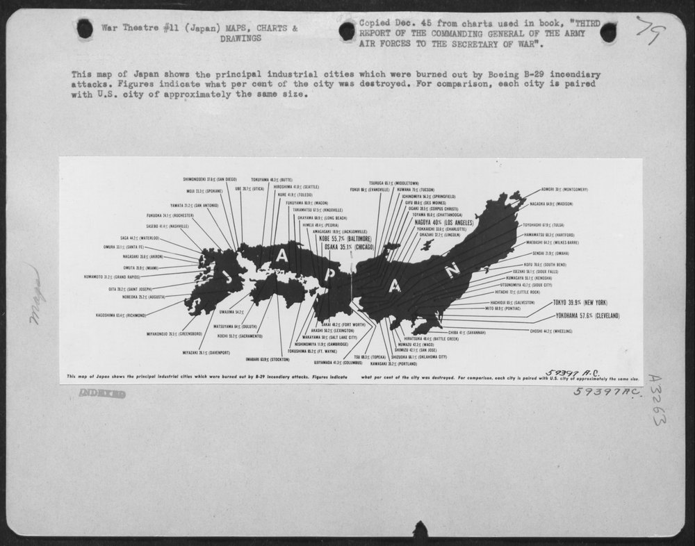
This map of Japan shows the principal industrial cities which were burned out by Boeing B-29 incendiary attacks. Figures indicate what per cent of the city was destroyed. For comparison, each city is paired with U.S. city of approximately the same size. SHIMONOSEKI 37.8% (SAN DIEGO) MOJI 23.3% (SPOKANE) YAWATA 21.2% (SAN ANTONIO) FUKUOKA 24.1% (ROCHESTER) SASEBO 41.4% (NASHVILLE) SAGA 44.2% (WATERLOO) OMURA 33.1% (SANTA FE) NAGASAKI 35.8% (AKRON) OMUTA 35.9% (MIAMI) KUMAMOTO 31.2% (GRAND RAPIDS) OITA 28.2% (SAINT JOSEPH) NOBEOKA 25.2% (AUGUSTA) KAGOSHIMA 53.4% (RICHMOND) MIYAKONOJO 26.5% (GREENSBORO) MIYAZAKI 26.1% (DAVENPORT) UWAJIMA 54.2% MATSUYAMA 64% (DULUTH) KOCHI 55.2% (SACRAMENTO) IMABARI 63.9% (STOCKTON) TOKUYAMA 48.3% (BUTTE) UBE 20.7% (UTICA) HIROSHIMA 41.8% (SEATTLE) KURE 41.9% (TOLEDO) FUKUYAMA 80.9% (MACON) TAKAMATSU 67.5% (KNOXVILLE) OKAYAMA 68.9% (LONG BEACH) HIMEJI 49.4% (PEORIA) AMAGASAKI 18.9% (JACKSONVILLE) KOBE 55.7% (BALTIMORE) OSAKA 35.1% (CHICAGO) SAKAI 48.2% (FORT WORTH) AKASHI 50.2% (LEXINGTON) WAKAYAMA 50% (SALT LAKE CITY) NISHINOMIYA 11.9% (CAMBRIDGE) TOKUSHIMA 85.2% (FT. WAYNE) UJIYAMADA 41.3% (COLUMBUS) TSURUGA 65.1% (MIDDLETOWN) FUKUI 86% (EVANSVILLE) KUWANA 75% (TUCSON) ICHINOMIYA 56.3% (SPRINGFIELD) GIFU 68.5